Zoning Tool
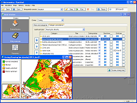
As of version 4.2, Metronamica can be equipped with an advanced model for spatial planning that offers more possibilities and is more directly linked with the policy making process than the older model. The Zoning Tool allows you to import maps representing zoning plans. Each category in such a map can then be interpreted as a zoning rule or regulation by specifying a zoning status for each land use — for example: strictly restricted, weakly restricted, allowed or actively stimulated. Furthermore, the start and end time of each category can be set, because different zoning regulations commence at different times. You can indicate precedence in the set of all zoning regulations to indicate that one plan overrules another in case of conflict. Note that all this functionality is directly accessible through the policy user interface.
What results is a time line of zoning maps depicting the zoning status for each land use. These maps are corrected for the current (De Facto) land use to prevent an existing land use from disappearing from a location when it becomes restricted.
Click the screenshot below to enlarge it.


